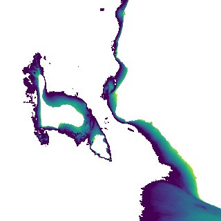
ga_s2ls_intertidal_cyear_3_x131y172_2020--P1Y_final.stac-item
dataset of product ga_s2ls_intertidal_cyear_3
Indexed by odc_admin
,
created
Region
x131y172
for
1st January 2020
Fields 🔗
creation_time
2024-03-28 09:13:52
dataset_maturity
final
eo_gsd
10.0
format
GeoTIFF
id
c727692a-1566-4851-bea3-85674522be91
instrument
ETM_OLI_TIRS_MSI
intertidal_hat
3.19
intertidal_hot
2.01
intertidal_lat
-3.85
intertidal_lot
-3.45
intertidal_offset_high
16.74
intertidal_offset_low
5.76
intertidal_otr
5.46
intertidal_spread
77.51
intertidal_tr
7.04
intertidal_tr_class
macrotidal
label
•
lat
-13.309 to -13.011
lon
129.963 to 130.258
platform
landsat-7,landsat-8,sentinel-2a,sentinel-2b
product_family
intertidal
region_code
x131y172
time
2020-01-01 00:00:00 to 2020-12-31 23:59:59