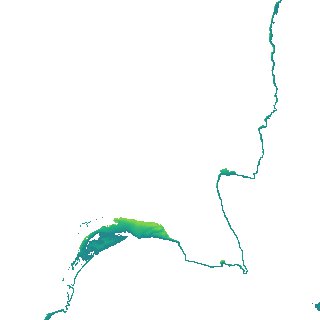
ga_s2ls_intertidal_cyear_3_x154y103_2021--P1Y_final.stac-item
dataset of product ga_s2ls_intertidal_cyear_3
Indexed by odc_admin
,
created
Region
x154y103
for
1st January 2021
Fields 🔗
creation_time
2024-03-26 03:30:46
dataset_maturity
final
eo_gsd
10.0
format
GeoTIFF
id
9827a099-006e-4e18-b2c6-8ff6f5ed5730
instrument
ETM_OLI_TIRS_MSI
intertidal_hat
1.66
intertidal_hot
1.31
intertidal_lat
-1.49
intertidal_lot
-0.74
intertidal_offset_high
11.19
intertidal_offset_low
23.75
intertidal_otr
2.05
intertidal_spread
65.06
intertidal_tr
3.15
intertidal_tr_class
mesotidal
label
•
lat
-33.052 to -32.753
lon
137.508 to 137.868
platform
landsat-7,landsat-8,landsat-9,sentinel-2a,sentinel-2b
product_family
intertidal
region_code
x154y103
time
2021-01-01 00:00:00 to 2021-12-31 23:59:59